Geospatial techniques refer to the methods and tools used to collect, analyze, and visualize spatial data. This type of data includes any information that has a geographic or location-based component, such as the coordinates of a landmark or the boundaries of a city. Geospatial techniques have become increasingly important across various industries, including urban planning, agriculture, environmental management, and disaster response. These techniques allow professionals to make informed decisions by leveraging location-based data, enhancing efficiency, accuracy, and problem-solving.
In recent years, advances in technology such as Geographic Information Systems (GIS), remote sensing, and GPS have revolutionized how we interact with the world. These tools provide critical insights into the physical world, making geospatial techniques essential in modern data analysis and decision-making processes.

Understanding the Basics of Geospatial Techniques
Geospatial data forms the backbone of geospatial techniques. It refers to any data that is tied to a specific location on Earth. This can include a wide range of information, from satellite images to data gathered through GPS devices.
What is Geospatial Data?
Geospatial data is a type of data that has a geographic aspect—essentially, it tells you where something is located. For instance, GPS coordinates, street addresses, or even temperature readings that are tied to a specific area are all examples of geospatial data. This data can be used to answer questions like:
- Where are the highest levels of air pollution in a city?
- What is the shortest route between two points?
- How is a forest area changing over time?
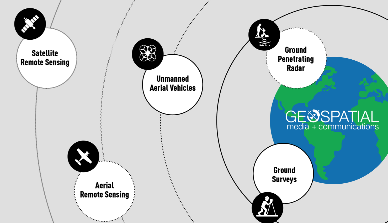
Geospatial data can be collected through various means, such as satellites, drones, sensors, and even smartphones. The data is typically categorized as spatial (related to location) and non-spatial (related to other information, like population data or rainfall measurements).
| Type of Data | Examples |
|---|---|
| Spatial Data | Coordinates, boundaries |
| Non-Spatial Data | Population, temperature |
Understanding the difference between spatial and non-spatial data is essential, as most geospatial techniques focus on analyzing spatial data to understand patterns, trends, and relationships.
How Geospatial Techniques Work
Geospatial techniques involve several stages, from data collection to analysis. Below is a simplified breakdown of the process:
- Data Collection: Information is gathered from various sources, such as satellite imagery, GPS devices, or surveys.
- Data Processing: Once the data is collected, it must be processed to ensure accuracy and relevance. This may involve cleaning the data or converting it into a usable format.
- Data Analysis: The processed data is then analyzed using tools like GIS software to identify trends, correlations, or insights.
- Visualization: Finally, the results of the analysis are presented in an easily interpretable format, such as maps, charts, or reports.
Geospatial tools, such as GIS software, play a critical role in this process. They allow users to store, analyze, and visualize large amounts of spatial data, making it easier to interpret complex geographical information.
Geospatial techniques bridge the gap between raw data and actionable insights by using specialized tools and processes. These techniques are essential for analyzing geographic phenomena and solving location-based challenges.

Geospatial Techniques and Their Applications
Geospatial techniques encompass a variety of tools and methods that allow professionals to collect, analyze, and interpret spatial data. Each technique serves different purposes, depending on the type of data being analyzed and the industry in which it’s being applied. Below, we explore some of the most important geospatial techniques and how they are used in real-world applications.
Geographic Information Systems (GIS)
What is GIS?
Geographic Information Systems (GIS) are one of the most widely used geospatial techniques. GIS is a computer-based tool that allows users to store, manipulate, analyze, and visualize spatial data. Essentially, it’s a powerful system that can map, model, and analyze spatial relationships, making it an invaluable tool for understanding geographic patterns and trends.
How GIS Is Used
GIS helps organizations visualize spatial data in the form of maps, which can reveal important insights. For example, city planners use GIS to map infrastructure, zoning regulations, and environmental factors when planning new developments. In agriculture, farmers use GIS to monitor crop conditions and manage resources more efficiently.
- Common applications of GIS:
- Urban Planning: City planners use GIS to analyze traffic patterns, population density, and land use.
- Environmental Management: GIS is crucial for monitoring deforestation, tracking endangered species, and managing natural resources.
- Healthcare: GIS can be used to map disease outbreaks and plan healthcare facilities based on population needs.
Example Case Study: Urban Planning with GIS
In cities like New York, GIS has been used to optimize public transportation routes by analyzing traffic data, population density, and road conditions. This has resulted in more efficient routes, reduced congestion, and improved public services for citizens.
Remote Sensing
What is Remote Sensing?
Remote sensing refers to the process of collecting data about the Earth’s surface without making physical contact with it. This is typically done through satellites or aircraft equipped with sensors that capture images or data about the Earth. Remote sensing is a key technique for gathering information about large areas quickly, making it particularly useful in environmental monitoring and disaster management.
How Remote Sensing Works
Remote sensing tools use electromagnetic radiation to detect and measure characteristics of the Earth’s surface. This data can then be used to create maps, track environmental changes, or monitor the impact of human activities.
- Applications of Remote Sensing:
- Environmental Science: Monitoring deforestation, changes in land use, and the health of ecosystems.
- Disaster Management: Identifying areas affected by floods, wildfires, or other natural disasters.
- Military Use: Mapping terrain and monitoring strategic areas.
Example Case Study: Deforestation Monitoring
The Amazon rainforest has been extensively monitored using remote sensing technologies. Satellites provide near real-time data, allowing conservationists and governments to track illegal logging activities and deforestation rates. This data helps inform policies aimed at preserving one of the world’s most critical ecosystems.
Global Positioning System (GPS)
What is GPS?
The Global Positioning System (GPS) is a satellite-based system that allows users to determine their exact location on Earth. Originally developed for military purposes, GPS has become a ubiquitous tool used for navigation, mapping, and location tracking across a wide range of industries.
How GPS Technology Works
GPS works by using a network of satellites that send signals to a GPS receiver, which then calculates the user’s position based on the time it takes for the signals to reach the receiver. This technique provides highly accurate location data, often down to a few meters.
- Applications of GPS:
- Transportation and Navigation: GPS is used in vehicles, smartphones, and navigation systems to provide directions and track movement.
- Logistics and Supply Chain Management: Companies use GPS to track the location of goods and manage deliveries.
- Scientific Research: GPS is used in research fields like geology, where it helps monitor the movement of tectonic plates.
Example Case Study: GPS in Transportation
Ride-sharing services such as Uber and Lyft heavily rely on GPS technology to match drivers with passengers, provide accurate navigation, and optimize routes. This use of GPS has revolutionized the transportation industry by providing real-time location data to both drivers and passengers.
Photogrammetry
What is Photogrammetry?
Photogrammetry is a technique that involves taking measurements from photographs, particularly aerial images, to create maps, 3D models, and other spatial data products. Photogrammetry is often used in engineering, architecture, and land surveying to measure distances, create accurate models of structures, and map terrain.
How Photogrammetry Works
Using a series of overlapping photographs, photogrammetry software calculates the distance between objects and generates accurate 3D models. These models can then be used in fields such as construction and environmental management.
- Applications of Photogrammetry:
- Construction and Architecture: Creating accurate 3D models of buildings and structures.
- Land Surveying: Mapping large areas of land for development or environmental conservation.
- Engineering: Photogrammetry is used to monitor changes in infrastructure, such as dams and bridges.
Example Case Study: Photogrammetry in Construction
In modern construction projects, photogrammetry is used to create detailed 3D models of building sites. This technology helps project managers plan and execute their designs more efficiently, reducing costs and improving accuracy. For example, photogrammetry was used in the construction of the Panama Canal expansion, ensuring precision in the design and construction phases.

LiDAR (Light Detection and Ranging)
What is LiDAR?
LiDAR (Light Detection and Ranging) is a remote sensing technology that uses laser beams to measure distances to the Earth’s surface. This technique enables the creation of highly accurate, high-resolution maps of physical environments, which are invaluable in fields like forestry, archaeology, and environmental science. LiDAR works by sending out laser pulses from a sensor and measuring the time it takes for the light to reflect back from the ground or object, thus calculating precise distances.
How LiDAR Works
LiDAR operates by emitting laser pulses that bounce off surfaces such as trees, buildings, or the ground. The time it takes for the laser to return to the sensor is recorded and converted into distance measurements. This data is then processed to create 3D models or digital elevation maps, giving a detailed representation of the terrain or object being studied. LiDAR systems are usually mounted on aircraft, drones, or even ground-based vehicles.
- Key applications of LiDAR:
- Forestry and Environmental Management: LiDAR is used to measure forest canopy height, tree density, and land elevation changes. This helps in monitoring deforestation and ecosystem health.
- Archaeology: Archaeologists use LiDAR to detect and map ancient structures that are hidden under dense vegetation or soil.
- Urban Planning and Infrastructure: LiDAR helps city planners create detailed 3D maps of urban landscapes for future development.
Example Case Study: LiDAR in Archaeology
One of the most impressive applications of LiDAR technology occurred in Guatemala, where archaeologists used it to uncover over 60,000 previously unknown structures from the Maya civilization hidden beneath dense jungle. LiDAR allowed researchers to see through the canopy and create detailed 3D maps, revolutionizing our understanding of this ancient civilization. This breakthrough would have been nearly impossible using traditional excavation methods, underscoring LiDAR’s transformative impact on archaeological discovery.
The Role of Geospatial Techniques in Modern Industries
Geospatial techniques play a pivotal role in numerous industries, driving innovation, improving efficiency, and enhancing decision-making. We will explore the impact of geospatial techniques across key sectors such as agriculture, environmental conservation, urban planning, and disaster management.
Agriculture and Precision Farming
How Geospatial Techniques Optimize Agriculture
In agriculture, geospatial techniques such as GIS, GPS, and drones are used to monitor and manage crops, soil health, and irrigation systems. This practice, known as precision farming, helps farmers make data-driven decisions to improve crop yields, reduce water usage, and minimize the use of fertilizers and pesticides.
Applications in Precision Farming:
- Soil Monitoring: GIS maps are used to identify areas of the field that require different treatments, optimizing resource use.
- Crop Health Monitoring: Remote sensing techniques help track the health of crops over large areas, identifying issues like pests or drought conditions early.
- Efficient Resource Management: GPS-guided tractors allow for precise planting, reducing overlap and waste, while drones provide real-time surveillance of large agricultural plots.
Example Case Study: Precision Farming in the U.S. Corn Belt
Farmers in the U.S. Corn Belt have adopted precision farming techniques to maximize efficiency. Using a combination of GIS and GPS, these farmers can map their fields, apply variable-rate fertilizers, and monitor crop health through drone surveillance. This has led to increased yields and reduced costs, making farming more sustainable and profitable.
Environmental Monitoring and Conservation
Tracking Environmental Changes with Geospatial Techniques
Geospatial techniques are critical in monitoring environmental changes, such as deforestation, glacier melting, and wildlife population shifts. By leveraging data from remote sensing and GIS, environmental scientists can track changes in ecosystems and biodiversity over time, helping inform conservation strategies.
Applications in Environmental Science:
- Deforestation Tracking: Remote sensing technology is used to monitor forest cover changes in real-time, providing data that supports reforestation efforts and combats illegal logging.
- Wildlife Habitat Monitoring: GIS tools are used to map and protect wildlife habitats, ensuring that species at risk are safeguarded from human encroachment.
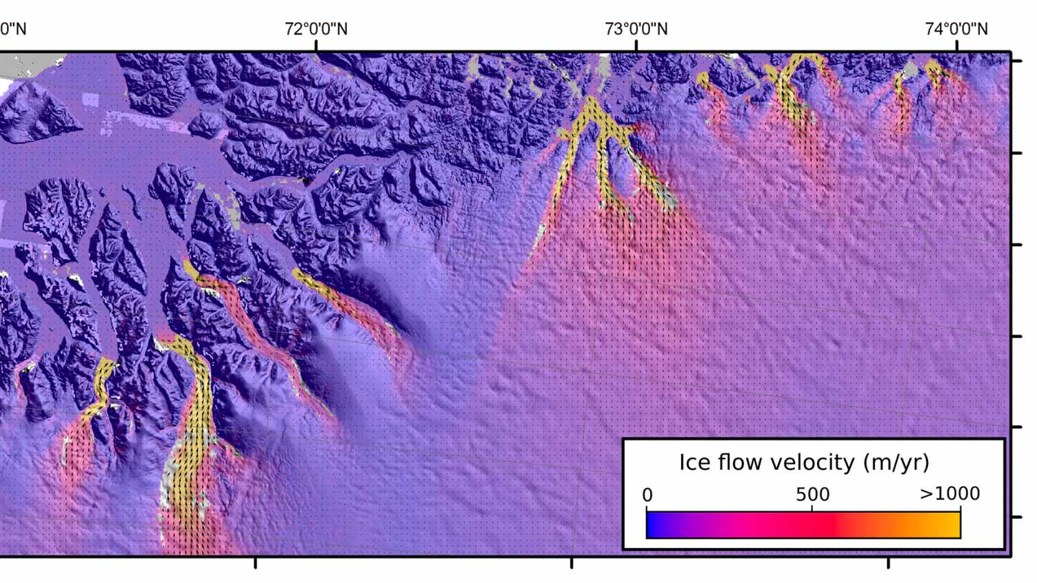
- Climate Change Monitoring: LiDAR and remote sensing are used to study changes in ice sheets, glaciers, and sea levels, providing crucial data on climate change’s impact.
Example Case Study: Deforestation Monitoring in the Amazon Rainforest
The Amazon rainforest is often referred to as the “lungs of the Earth,” but deforestation has been a critical issue for decades. Through the use of remote sensing and GIS, environmental organizations have been able to track illegal logging activities and monitor the overall health of the forest. This data has been instrumental in creating policies to protect the rainforest and mitigate the effects of deforestation.
Urban Planning and Smart Cities
How Geospatial Techniques Shape Urban Development
Urban planners use geospatial techniques to design cities that are efficient, sustainable, and equipped to handle population growth. By using GIS and remote sensing, planners can visualize land use, infrastructure, and natural resources, enabling more informed decisions that benefit residents and the environment.
Applications in Urban Planning:
- Infrastructure Development: GIS is used to plan roads, public transportation systems, and utilities by analyzing traffic patterns, land use, and population density.
- Sustainable City Design: Geospatial techniques are used to create “smart cities” that integrate technology into infrastructure, improving energy use, waste management, and public services.
- Disaster Risk Assessment: Remote sensing and GIS are used to assess flood plains, earthquake risks, and other environmental factors that affect urban areas.
Example Case Study: Smart City Planning in Singapore
Singapore is a leader in smart city development, using geospatial techniques to optimize everything from transportation systems to energy efficiency. GIS is integrated into Singapore’s urban planning to monitor traffic congestion, manage public utilities, and reduce environmental impact. This approach has helped Singapore become one of the world’s most efficient and sustainable cities.
Disaster Management and Risk Assessment
Using Geospatial Techniques for Disaster Preparedness
In disaster management, geospatial techniques are essential for assessing risks, predicting natural disasters, and managing responses. Remote sensing, GIS, and GPS are used to map hazard zones, track the movement of storms, and assess damage after disasters occur.
Applications in Disaster Management:
- Flood Risk Mapping: GIS and remote sensing help identify flood-prone areas, allowing authorities to plan evacuation routes and implement flood mitigation measures.
- Earthquake Monitoring: GPS technology is used to track tectonic movements, providing early warnings for potential earthquakes.
- Damage Assessment: After a disaster, remote sensing and aerial imagery are used to assess the extent of the damage and prioritize recovery efforts.
Example Case Study: Earthquake Monitoring in Japan
Japan, located in one of the most seismically active regions of the world, uses a combination of GPS and GIS to monitor tectonic plate movements and assess earthquake risks. These systems have helped create early warning systems that provide critical seconds of warning before an earthquake strikes, reducing casualties and damage.